Democrats blasted George W. Bush not just for FEMA’s operations, but also because he flew over New Orleans after Katrina, choosing not to land and be a distraction.
Now, Joe Biden is at the beach.
People are dying in the mountains of North Carolina and Joe Biden can’t even be bothered to get off the beach and back to the White House. He claims he’s working the phones.
At times like this, it matters as much that Presidents look like they’re engaged, not just that they are engaged. Hanging out on the beach does not look very engaged.
For Democrats, this is a swing state with a Republican gubernatorial candidate in scandal. They could win it. But the President embracing the salt life as some people are just trying to stay alive is going to resonate. The pictures will matter. Yes, the optics matter.
Beyond that, Joe Biden’s National Weather Service got its projection wrong.
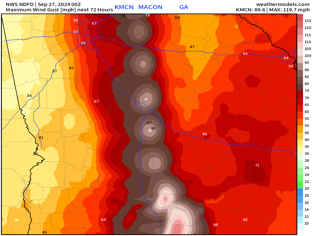
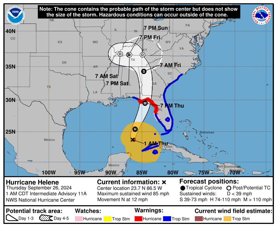
People who believed the private sector modeling were informed, but most news networks relied on the National Weather Service, which projected the eye going up I-75 through Macon, Georgia, where I live.
In fact, the National Weather Service projected the center up the eye would go straight up my street. But other, better weather models showed the storm moving East. Private sector services, like power companies, relied on those better models to position resources anticipating the storm.
Individual and the government, relying on the National Weather Service, expected a storm much further west than it was. The National Weather Service is controlled by the Biden Administration. It may be non-partisan, but it is under the President’s control.
While the President was living his best life on the beach, the National Weather Service modeling got the track of the storm wrong and a whole lot of people died because of it. Below is a representation of the NWS data that was put out and that a lot of local television weather forecasters used. It was not accurate. The path of the storm went east.
Tracking a massive hurricane is not precise. But others provided better insight and predictions than the National Weather Service. Private sector and other government models showed that it would go east, over Augusta, Georgia, and into North Carolina.
Sadly, those who relied on the government data to position their resources could not then get into North Carolina to help because the roads washed away. Better public data would have allowed more accurate resource positioning before the storm hit.
Does Joe Biden, on the beach, even care?


That is a big fat NO. My heart bleeds for those affected by the hurricane. It seems the only one prepared was Governor DeSantis. He already has 99% of the power back on.
There are people still missing and the ones that survived have nothing and won’t have a for a very long time. Mr President get off your damned beach chair and help these people.
Do I dare say anything about the longshoremen going on strike wanting a 70% pay increase over 6 years, how absurd. Who gets that? Maybe since they aren’t doing anything they can help with the hurricane cleanup.
I am no weather expert. And, what I am going to say is not, in any form, an expert opinion. But, I have been around a few years.
A general rule of thumb is that, if the center of the track is west of the Apalachicola National Forest, a hurricane will track almost due north and, east of that forest, it will track northeasterly. Usually, only if the storm is already moving northeast will that play differently. There's a few factors at play.
1. The storms that are moving closer to northerly are going to be west of that point. If they are not moving north, they are likely going to start crossing the Florida peninsula before they get near Georgia.
2. These storms have a wind rotation of counter-clockwise so they already "want" to move northeast due to wind resistance of the ground. (Yeah, sounds far-fetched and made up.)
3. Other, typical weather patterns north of Florida usually come from the west (northwest, southwest) so they are going to tend to push storms east.
4. This is more observation on my part. The Appalachian Mountains tend to really get started around Chattanooga and run on a (roughly) 45 degree angle northeast through east Tennessee. If a storm can get up around Huntsville, it stands a good chance of heading toward the state of Kentucky before the typical weather patterns push it east. If it is in Georgia before it reaches the Tennessee line, in all likelihood, it is going to be forced into a northeasterly track up the east side of the mountains.
But, that's pure speculation on my part.